Gary Crabbe Stamps
DEATH VALLEY
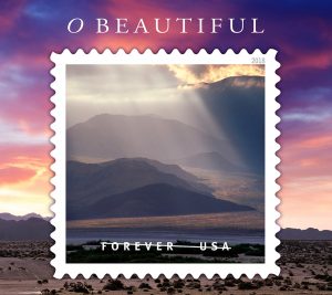 Sunlight and storm clouds on Panamint Mountains, Death Valley National Park, California
ID # DVA-1316
I remember the trip where I shot this image for two primary reasons. The foremost reason: This was the last travel shoot I did using film before switching to digital. Second, the spring of 2005 was a very wet and stormy year and was attracting the attention of photographers and wildflower hunters for being a rare “Super Bloom.” In fact, the rains turned part of the desert floor into a huge lake. On this particular trip, I spent about a week photographing throughout Death Valley National Park.
On this particular day, the storm clouds started building and by noon the winds had kicked up a huge dust storm. After the storm cleared, I went for a short hike in nearby Golden Canyon. I then noticed some tiny bits of sunlight coming through the clouds over the Panamint mountain range to the West.
As I was hiking out of the canyon, I noticed these light beams — also called crepuscular rays — had gotten much more intense due to all the dust in the air. The sunbeams appeared directly over an area known as an alluvial fan, a geology term for a place where rocks and dirt get washed down off the mountainside during rainstorms. One of the things I knew as a photographer was these sunbeams could actually appear more dramatic in a photograph than with a naked eye. As a landscape and travel photographer, I’ve always made it a practice to take a photo whenever I see some kind of special light happening in nature. I was really lucky because just a couple moments after I took this photo, the sun dipped behind the clouds and this special light completely disappeared. — See more of my Death Valley photos.
MERCED
 Hawk on top of rural windmill next to wooden water tank at sunset, Merced Grasslands, Central Valley, California
ID# MRCD-1041
In the early 2000s, the University of California was planning on building a new campus outside the Central Valley city of Merced. I was hired by The Nature Conservancy for an assignment documenting some of the fragile natural environments on the grasslands leading up to the base of the western Sierra Foothills. These included features like vernal pools, fairy rings, and the slightly mysterious Mima Mounds. One of the biggest challenges for The Nature Conservancy was to develop a good and mutually beneficial relationship with the ranchers and farmers. It was fairly well known that these two groups often stood slightly apart on their perspective regarding environmental use and protections. Many people outside of California don’t realize what a huge agricultural industry and economic base this state represents, so working well and setting up these good relationships with the farmers and ranchers to help preserve some critical natural resources has been a highly sought-after goal.
Spending several days in the area working on this assignment and having free reign to drive around alone in my truck on some of those beautifully unspoiled ranches at the base of the western Sierra was a truly delightful opportunity. At the end of my last day, a spring storm had started to move into the area, and grey skies blanketed the region. I figured my work was done. Just as the sun started to set, the light was able to get underneath the storm clouds. I drove past this bucolic scene of a water tank with a hawk perched atop an old rusted windmill. The scene instantly reminded me of something I might see more easily in Nebraska than thinking of something from California which compelled me to stop and take the photo. (Normally, hawks are very skittish and sensitive when you get too close to them. Here I was lucky to be at enough of a distance where the hawk didn’t feel too spooked to fly off.)
HALF DOME – YOSEMITE
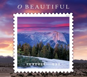 Alpenglow on clouds at sunset above Half Dome and Tenaya Canyon, Yosemite National Park, California ID# YOS-1064b_YB
As a landscape photographer, one of the high ideals that we tend to seek out is a combination of great views complemented by great light. Often clearing storms are the perfect vehicles for providing some of that special light that we chase. During the summer months, warm moist air moving in from the Pacific Ocean gets heated even more as it moves across California Central Valley before getting pushed up higher into the atmosphere by the peaks of the High Sierra. The result is a wonderful cycle of building afternoon thunderstorms that move across the Sierra Nevada with incredibly dark clouds and occasionally heavy rain. This was one of those days. I actually chose to drive up to Yosemite from the Bay Area after carefully watching and studying the weather reports. I had this Vision in my head of trying to get some impressive Stormlight over one of the huge Granite icons of Yosemite like Half Dome or El Capitan. I think I was hoping most to get some kind of rainbow arcing over the side of Half Dome. As I drove into Yosemite Valley, I could see nothing but incredibly dark clouds covering Half Dome. Rather than stay in the valley, I opted to drive up toward the incredibly impressive vista called Glacier Point.
Due to the rainy weather, I found unusual solitude as I decided instead to hike from Glacier Point Road to the top of Sentinel Dome to spend a few hours waiting out the end of the storm. As the sun began to set, the rain had stopped and thunderstorm clouds started to part. Alas, I never did get a rainbow on this day, but the clouds did part enough to allow this incredibly pinkish-red light to bathe some lenticular clouds that were above Half Dome and Tenaya Canyon. That special light has its own name — Alpenglow — which comes from the reddish color of the light scene on the high peaks of the European Alps at sunrise or sunset. – See more of my Yosemite photos.
CRATER LAKE
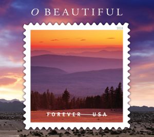 Sunset looking west over the hills from the rim of Crater Lake, Crater Lake National Park, Oregon ID # CLNP-0509
This image was taken quite early in my photography career. My wife and I had just gotten married a few years before and were on one of our first few annual vacations where I was taking pictures and working at improving my photography. (I was very fortunate that I had a great teacher.)
This was our first trip to Crater Lake, and other than the many classic postcard views, I wasn’t really sure what to expect on our arrival. What greeted us was truly one of the most impressive natural sights with a volcanic crater filled with the most crystal clear Deep Blue Water you could imagine outside of the ocean.
One of the things I was trying to work on at that time was to develop myself more as a travel photographer who loved landscapes rather than a landscape photographer who just sought out only the most dramatic and well-known postcard vistas. For me, that meant paying attention to the other scenery and natural features of the park beyond its namesake cradled body of water.
Driving around the west side of the lake just after sunset, I was immediately taken by this incredible vista looking off toward the west with the repeating lines of ever more distant ridges receding toward the horizon. Having spent part of my childhood growing up and traveling along the East Coast, it was the closest thing I could imagine seeing that reminded me of the Great Smoky Mountains in the Appalachian Range. As I stood looking out over this scene, I marveled at the fact that just over the most distant visible range lay the Pacific Ocean and the beautiful Oregon coast. At that moment I thought back to what it must have been like for some of the early explorers who followed in the footsteps of Lewis and Clark and how they must have felt upon first scene these sights for themselves.
This scene was so special to me that I decided right then and there to return the very next day to see how different this location would look photographed in early morning light. To this day, nearly 25 years later, I still use this sunset shot and its companion morning shot from the next day in my photo workshops and presentations to show photographers how different a scene can look when photographed twelve hours apart and why it is important to return to locations on different days and different times to really capture a feeling and sense of a place.
ORINDA HILLS
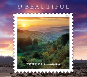 Spring sunrise over green hills, near Orinda, Contra Costa County, California ID# LMO-1099aM
I was incredibly grateful that for the first 6 years as I started my career in the world of photography, this scene was part of my daily commute. Living in the nearby town of Lafayette, I joined the daily grind of commuters hopping on the freeway heading towards Oakland or San Francisco. But after just a few miles, I was lucky enough to hop over the Berkeley Hills by taking one of the most scenic roads in the entire Bay Area, twice a day – five days a week.
As I started on my own path as a photographer, I would sometimes keep a camera in my car just in case there was a nice Sunset to accompany my drive home. But even on those days when I didn’t have a camera, I was learning to think more and more like a photographer by watching locations change throughout the year in terms of both the seasonal colors on the landscape as well as the weather and timing of sunrise and sunsets.
After many trips through the area, and often stopping to take photos as they were available, I began to learn more about previsualizing scenes and anticipating certain natural phenomena like when and where the sun or moon will rise or set.
This particular shot was planned in advance knowing that within the week of the Spring equinox, the sun would rise directly over our neighboring landmark, Mount Diablo. On the couple days when the sun was rising directly behind the peak, I made sure to wake up early and be on location before sunrise and then wait for the right moment while sipping coffee. The first couple days were marred by spring storms, but on the third day after the storm cleared, there was a beautiful sunrise with the sun coming up just behind the mountain and over this rolling valley landscape that forms the eastern side of the Berkeley-Oakland Hills. — See more of my East Bay photos.
VINEYARD
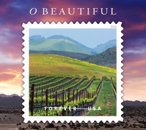 Rows of wine grape vines in vineyard and green hills in Spring, Edna Valley, San Luis Obispo County, California ID# SLO-2066
This image is really one of those third or fourth time is the charm-type shots.
I’ve grown up here in the San Francisco Bay Area just a stone’s throw from the Napa and Sonoma wine country. I first became aware of this location while working with an author on my fourth book, Backroads of the California Wine Country. I was attracted to the rows of grapevines leading up towards the repeated ridgelines in the background.
The first time I came through this area was in the fall just as I was wrapping up my book project. At the time I was shooting film and I remember clearly getting a phone call from a guy at my photo lab who said, “Dude, is something wrong with your camera?” I said, “I don’t think so; why?” He proceeded to tell me that nearly 50 rolls of my film — out of 120 rolls that I shot over several weeks — turned out nearly entirely black. Because film cameras didn’t have an LCD screen on the back of the camera where you can check your shot immediately after you took it, I had no idea that anything was wrong, even though my camera continued to sound like it was working perfectly. The shutter curtain in my camera had stuck closed and didn’t expose nearly a week’s worth of film. Rather than risk trying to delay my book project any further, I opted to head back down to this area and try and reshoot as much of the coverage as possible. However, on that second trip the light just wasn’t any good so I bypassed the area without taking any additional shots.
Fast forward a few years later: I was now working on my fifth book project called, Backroads of the California Coast. This time it was spring, but on my first time through the area, it was a cloudy, gray, rainy day. I spent a few more days along the Central California Coast between Cambria in Santa Barbara, finally again working my way back through the Edna Valley. On my return trip home I finally found this scene bathed in nice soft sunlight which allowed the yellow mustard flowers and fresh new green leaves on the grapevines to really stand out from the green grass and rock covered hills in the background. — See more of my California Wine Country photos.
MORGAN TERRITORY
 Sunset light on green hills in spring, Tassajara Region, near Livermore Contra Costa County, California ID# TAS-1092aM
I first became aware of this area after seeing a photograph of these hills published in a book by my former boss. As I started my own photography, I would occasionally take a drive through here to scout out the conditions and take an occasional photo. It took about four or five trips out to this location before I finally got this shot where I was really happy with the results. It has just the right combination of green grass in the hills, — they’re dry and brown most of the year – golden yellow warm sunset light, and a nice mix of atmospheric haze so the scene appears both clear yet colorful. (If the air is too clear, like just after a windy day, the sky has very little color.)
When I first moved to the San Francisco Bay Area as a young teenager, the San Ramon – Diablo Valley, and the Tri-Valley areas around Livermore, Pleasanton, and Dublin had some housing and stores but was not overly developed. Fast forward 35 years and these valleys have now been filled with high-density housing, residential tracts of large family homes, huge corporate offices, and numerous shopping malls. As I originally felt when I looked out over this scene years ago, I remain amazed that this type of bucolic setting is still able to exist in the midst of an incredibly fast-growing and crowded Bay Area. With thanks in part to some local non-profit organizations (like the Bay Area’s Greenbelt Alliance), there are still places within the bay area where you can easily feel as if you stepped back more than a hundred years in time, and this is one of those precious locations. — See more of my East Bay photos.

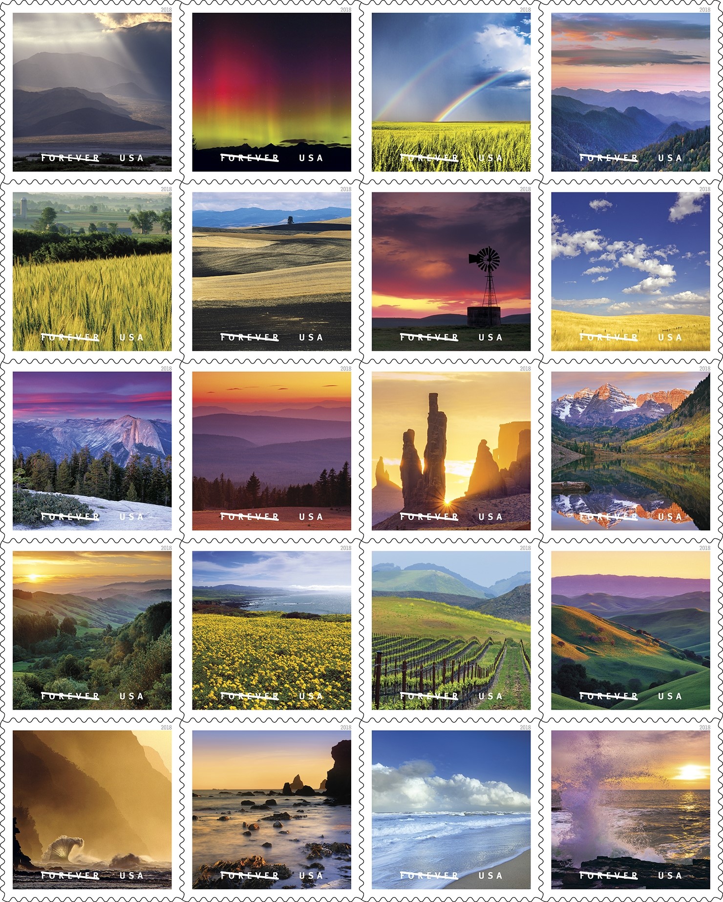
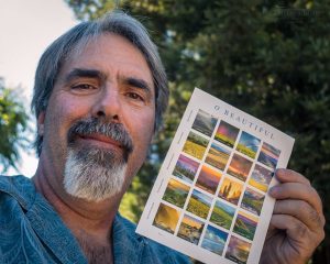 There is a photo agency* that works on behalf of the United States Postal Service that reached out to me in the early fall of 2016 saying they were interested in some of my images. I said, “Sure, sounds great,” … and that was the last I heard about it for six months. That in itself is never a big deal to photographers who work regularly with publishers or clients who have long lead times, and most of the time you don’t hear anything back — like it all drops off into a black hole. But then six months later in early March 2017, I received an email confirming the USPS has selected seven of my images.
 Sunlight and storm clouds on Panamint Mountains, Death Valley National Park, California
 Hawk on top of rural windmill next to wooden water tank at sunset, Merced Grasslands, Central Valley, California
 Alpenglow on clouds at sunset above Half Dome and Tenaya Canyon, Yosemite National Park, California ID#
  Sunset looking west over the hills from the rim of Crater Lake, Crater Lake National Park, Oregon ID #
  Spring sunrise over green hills, near Orinda, Contra Costa County, California ID#
  Rows of wine grape vines in vineyard and green hills in Spring, Edna Valley, San Luis Obispo County, California ID#
  Sunset light on green hills in spring, Tassajara Region, near Livermore Contra Costa County, California ID#