Picture: Funnel cloud descending on the rural outskirts of Tracy, Central Valley, California.
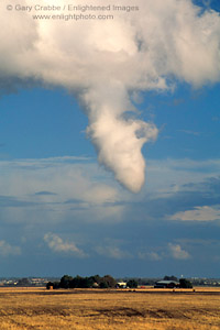
I’ve only been lucky enough to photograph one funnel cloud. It occured on a stormy afternoon in NOVEMBER. I had been returning from Yosemite National Park, after spending the whole first half of the day under deep dark rainclouds. You can actually see the storm clouds in the background stacked up against the Sierra. The funnel cloud lasted about 15 minutes, and the photo above shows it’s closest approach to the ground. Had the tip actually touched the ground, then – meteorologically speaking – it would have offically been classified as a tornado. Eventually, I’ll add these and similar images into my Clouds and Skies photo gallery. In the meantime, you can also see a close-up version in my New Images Portfolio.
Now, if you really want to see the KILLER tornado shots, there really is only one world-class, go to specialist, Warren Faidley. He’s the guy every stormchaser envies, having founded the photo agency, Weatherstock.
That is sooo cool. If you ever decide to give stormchasing workshops I’d definetely sign up. Last March when I was living in the Bay Area, two F2’s hit my neighborhood according to KRON 4. I had spent the rainy day in Napa Valley so I had no idea but saw some downed power lines when I got back. I found out on the news later that night. Tornadoes are awesome, I want to see one as long as they hit someone else’s house and not mine.